Eagle Creek Recreation Trail, Cascade Locks, Oregon
Many months ago, while all adventurers in the north were aching for winter to clear off trails so we could go back to the wilderness, J-Go and I had made a plan to backpack Eagle Creek Recreation Trail. Five years ago, this trail was closed due to the devastation caused by a teenage boy who was irresponsibly playing with fireworks and, as a result, started a forest fire that lasted three months and burned more than 48,000 acres in the Columbia River Gorge. More here. Over 150 hikers became trapped on the trail, and many were stuck overnight waiting for first responders to be able to rescue them. The teen earned five years of probation, almost 2,000 hours of community service, and over $35 million in restitution fines. The Pacific Crest Trail Association poured its hearts into making the trail accessible again – moving countless fallen trees and boulders on the trails, reestablishing campsites, and clearing other debris from the wilderness area to protect it from more damage. The trail reopened in 2021 while the world was battling the Covid-19 pandemic. I closely watched social media posts made by those hiking and backpacking the region, waiting for availability to do it myself. Of course, I was becoming increasingly sick then, eventually finding that I have cancer. As the date became closer for J-Go and me to put our feet on the dirt, I feared that my body would betray me again and that I would not make it. But I did.
This place is magical. First, the drive alone that is along the Columbia River is gorgeous. The trailhead, located near Cascade Locks, has a main parking lot and an overflow parking lot that extends your hike by .5 miles. We ended up in the overflow. There is a bathroom and a map at that location, but those things are not at the closest parking lot. Almost immediately after getting on the trail, you break through the trees to find yourself walking along the canyon wall on a somewhat narrow strip of land. Several sections of these canyon wall trails have strong cables for users to use a railing. I found that to be helpful on the wet sections.


Less than two miles on trail you will come to an intersection that tells you if you go to the right, you will go to Lower Punchbowl Falls. Of course, go right. It is a steep trail made of loose rocks, but you quickly get to the falls, which will likely be quite populated. If you look at the above photo, you can see the canyon narrows a bit on the upper left side. That goes to the main Punchbowl Falls, almost entirely blocked by huge boulders that had fallen from the canyon walls during the wildfire. I waded across the river and climbed the vast rocks, only to find more barriers between me and the falls. I wanted to keep going, and had I been backpacking alone, I would have. But I am not trying to traumatize my friends, so I gave in and waded through the river back to where the above photo was taken. You can see Punchbowl Falls without risking your life when you return to the main trail and keep hiking, but it is from above. Way less exciting. And my photos turned out stupid, so you must see it yourself.


There are many water crossings along the trail, with a couple of bridges. High Bridge is a popular turning point for day hikers. This was a suspension bridge before the wildfire that closed this recreation area. The fire caused a cable to snap, breaking the bridge. During the restoration of the trail, this new bridge was airlifted to the location and installed. More here. Without this bridge, there would be a significant increase in elevation gain and difficulty for hikers.


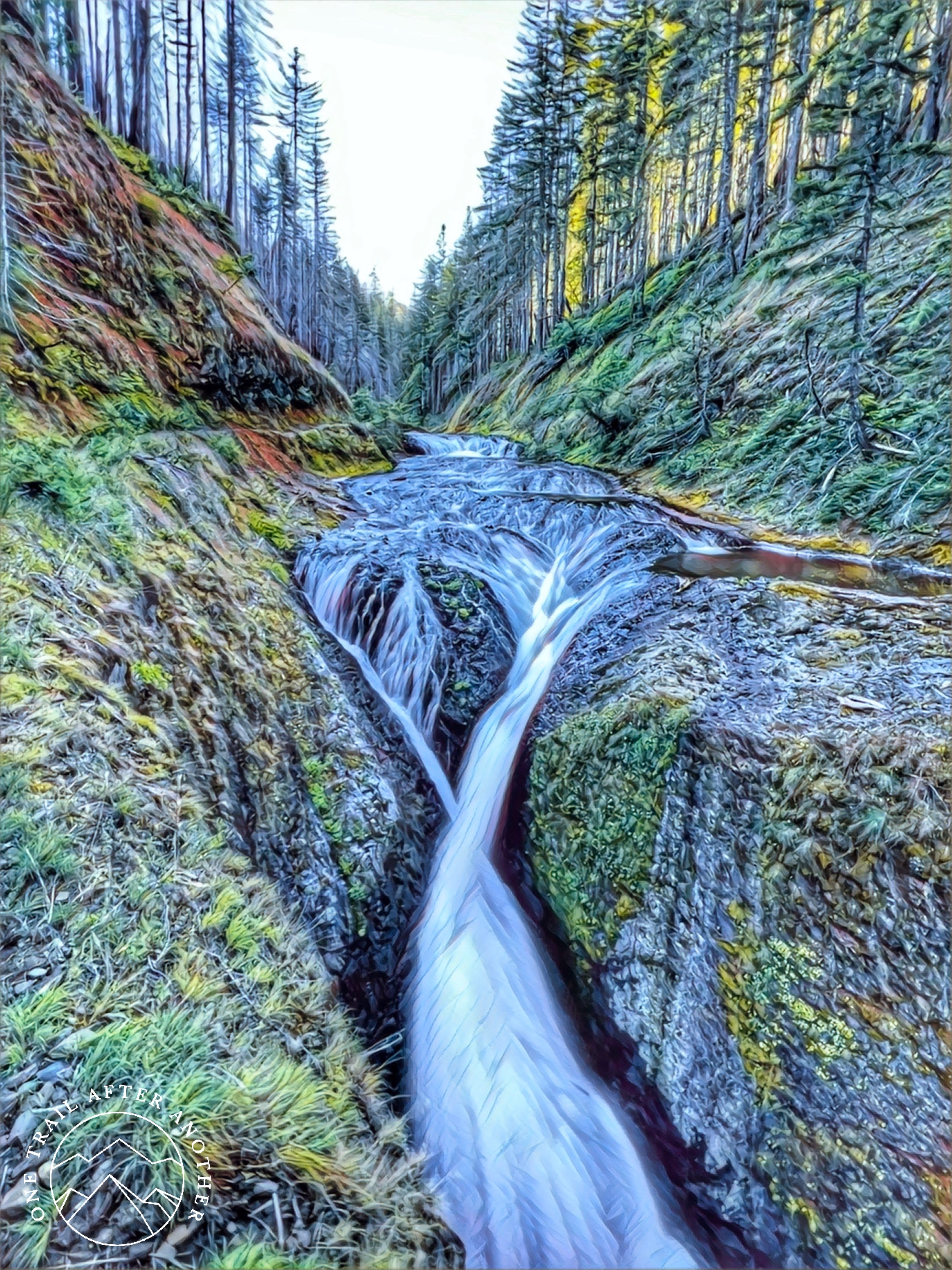
After High Bridge and Tenas Camp, you will see a few more unnamed waterfalls, Wy’East Camp and Wy’East Falls, Blue Grouse Camp, and Grand Union Falls. Many adventurers seek out Eagle Creek for Tunnel Falls. It is J-Go’s favorite thing from the trip. Eagle Creek Trailhead to Tunnel Falls is 6 miles, with a gradual elevation gain of a little over 1,500′. If you are tracking your mileage, you know that the view is coming up, but somehow it is still shocking and exciting when you turn the corner of the canyon, and this incredible waterfall is right before you. Tunnel Falls is 172 feet tall and plummets into a bowl-shaped area filled with rainbows and every shade of green in the most brilliant way you can imagine. The tunnel behind the falls is just long enough to become pitch black for a second. On each end of the tunnel, you are surrounded by incredible bright green ferns and mosses growing from all the surfaces and being sprayed by the waterfall’s power.

Shortly after Tunnel Falls, you will hike by Twister Falls. I think I liked this one the best. You can see the trail cut into the canyon wall on the left side of the photo, just feet above the falls. It is another view that surprises you when you turn a corner. Maybe I liked this one best because I was starting to decline in energy and knew that the camp we aimed for was less than two miles from this waterfall. When we arrived at the part of the trail above 7.5 Mile Camp, we saw that people were already setting up their camp. I do not usually like sharing camp, but I was tired after driving six hours and hiking over eight miles (our side quests added distance – the trailhead to this camp is more like 6-7 miles), so I called down to them asking if we could share. We could. There was not much tent space remaining, but we made do and ended up happy with our site. We were right at the top of a low waterfall, so we always had flowing water to filter from, and our campmates were wonderful. We initially thought it was a couple, but now we think it was a father and daughter duo, but most importantly, they had a dog. The man and the dog were deaf, so most of the communication went between the woman and us, but she was an incredible interpreter for him and us. Observing a deaf man and a deaf dog and their relationship was wonderful. Her name is Luna, and she is a Dogo Argentino. She was trained through sign language and almost always had at least one eye on the man. We were hers once she welcomed us to camp, and I was constantly covered in white dog hair. Dogs make everything better. On that note, there were countless dogs on this trail. Leashed, unleashed, some were in backpacks, front packs, and some wore doggles. It was incredible. But, since this does not appear to be common knowledge, when someone gets excited to see your dog and say, “Hi puppyyyyyy!”, they are talking to your PUPPY, not YOU, and it is not an open invitation to begin a conversation. Unless your name is Puppy, in which case I apologize.


We have a friend who is learning how to manage complex post-traumatic stress disorder (C-PTSD). She is beautiful, brilliant, and loving, and most days, she struggles to leave her bedroom, so her time in the wilderness, the place she loves the most is minimal. I have only had a few adventures with her and she is pure joy. Our friendship has been forged through the fire of supporting one another through all the ugliness of grief. This spring, she gave me an incredible gift of a new backpacking tent. She gave me an X-Mid 2p from the famous, cult-ish Durston. This tent gives me over twice the space of my previous tent without any added weight. I am not a wimp about carrying weight, but I would rather have my extra weight be in good food and drinks, not part of my base. I felt like a queen. Although my pitch was not perfect (ha! Pitch Perfect. Ah, nevermind), it was good, and it gave me all the space I needed while I struggled through living in this unwell body in the wilderness. More than that, I felt like I was taking a piece of her with me. She will be back on the trails, and maybe she can do it without packing all her sorrow. Even if her sorrow finds its way on trail, someday it will not be able to smother away the beauty that awaits her. Meanwhile, I have a piece of her to take with me, and I do not take it lightly (even if it is very lightweight. Ha! The jokes today.). I try not to pack my sorrow on the trail, but grief is not easily unloaded. More often than not, I find myself leaving some of that behind in the forest instead of not taking it in the first place. As I carried this precious gift and the thoughts of our friend on trail, I often wondered as J-Go and I passed people, how many of these people also had to fight unseen demons to get onto trail and how many of these people are here to unload some of those demons in their efforts to find life easier off trail.

After a good dinner, magical fungi, and a full night in our tents, J-Go and I hiked into the Mark O. Hatfield Wilderness Area to find Wahtum Lake and complete the Eagle Creek Trail. This was my favorite day. There are significantly fewer people in this section. We probably saw 200 people the day before. This day we saw six. This section produces a sharper incline but is still gradual. It was all burned down from the wildfire, but the entire trail is now lined with wildflowers, huckleberries, raspberries, strawberries, and butterflies. We even saw a spider murdering a butterfly. The brush in some sections is so full you have to push through it, and others remain bare. There are still waterfalls; they are just not as big as the previous day, and countless water crossings full of beautiful moss-covered rocks and boulders.


This day was beautiful. It was hard work with a constant payoff. If you were not enthralled by the flowers, butterflies, and creek crossings on the trail, then you can look away and be stunned by the burnt wilderness that reminds you how big we are and that every choice we make matters. Human-caused wildfires are a glaring reminder of how we do not get to choose the consequences of our actions and that some of our choices might change things forever. I wish our positive impacts were as easily cemented as our negative ones, but that is not how things seem to work. We can make one mistake and cause irreparable harm, but we must be committed to routinely doing good for good to have any impact at all.
We hiked 15 miles that day. Or 16. Somewhere in there. Returning to camp was fun because Luna was waiting for us. The last day at camp is always exciting because everyone knows they get to eat all the food left. I have poor nutrition in general, but I really struggle on trail. I have never liked having food near the window of working out, but that does not suit backpacking well – you must fuel yourself routinely on the trail to keep carrying weight and climbing. My meals were gluten-free tortillas wrapped around cabbage and lentils from Lentiful. It was delicious, but probably not enough calories for the workload.
The following morning, we woke up and packed up camp. J-Go did not love all of her photos from the first day and was excited for the hike out to capture some of these scenes in the morning light since we already had done it in the afternoon light. There were even more people this day than the first day we did this section. So many. A lot. I think actually ALL OF THE PEOPLE were there. This hike out was fast and easy, all at a gradual decline. We wanted to make it off trail before the 48-hour mark, and we did it precisely.


Even though there were 589,903 people on the first couple of miles of the trail, this really was incredible. Also, most of those people came with dogs, so there was a strong consolation to the human presence. Most people were day hikers, which was also a consolation. Eagle Creek Trail is beautiful. It was an experience to be in such a devastating place. Usually, we feel small in the wilderness amongst the ancient trees and giant mountains, but to be in a place completely burned down because of one small human, you are reminded that we are bigger than we might like to think.
Stats:
- 30.86 miles
- 4,364′ eg
Gear: (base 17lbs 6.74oz)
- Hyperlite Southwest 4400 (2lbs 8oz)
- Durston X-Mid 2p (2lbs 6.4oz)
- Therm-a-Rest Z Lite Sol sleep pad (r-value: 2.0) (14oz)
- NEMO Tensor Ultralight Insulated Sleeping Pad (regular-wide) (r-value: 4.2) (1lb 3oz)
- UGQ Bandit Top Quilt (specs: 800 fill, 30 degrees F/-1 degrees C, Reg/wide, no overstuffing, draft collar and zipper and drawcord foot box) (21oz)
- Jetboil Flash Cooking System (13.1oz)
- Jetboil Jetpower (did not weigh to see how much was left – 13.4oz when full)
- Sea to Summit Alpha Light Spork (.4oz)
- GSI Infinity Lightweight Backpacker Mug (3.5oz)
- Hilltop Packs Bear Bag and Dog Bone Hang (1.3oz)
- Osprey UL Roll Organizer (4.23oz)
- Vivago Biodegradable Bamboo toothbrush (.4oz)
- Schick Intuition Bamboo Shaver (.35oz)
- humangear GoTubb Small Containers (3) (.6oz) –
- —1. Simplut Toothpaste Tablets
- —2. Lumē Whole Body Deodorant
- —3. Aquaphor
- Conair Comb Detangle (3.2oz)
- Kula Cloth
- Hilltop Packs Zipper Pouch (large) (.48oz)
- Ziplock bag with clean toilet paper
- Ziplock bag with clean Water Wipes
- Ziplock bag for used TP and wipes
- TheTentLab Deuce Ultralight Backpacking Potty Trowel (size #2) (.6oz)
- My ten essentials:
- 1. Navigation: Compass and AllTrails map downloaded to my phone and McKenzie River & Old Cascade Crest, OR, Trail Map
- 2. Sun protection: did not bring
- 3. Headlamp: Nitecore NU25 360 Lumen Triple Output (.99oz)
- 4. First aid: Adventure Medical Kit.5 (.23lbs)
- 5. Fire: Zippo Emergency Fire Kit (.1 lbs)
- 6. Shelter: Life Bivy Emergency Sleeping Bag Thermal Bivvy (temperature rating to 14 degrees F) (4.1oz)
- 7. Knife: CRKT Minimalist Bowie Neck Knife (1.8oz)
- 8. Extra food: Tailwind Nutrition Endurance Fuel, Kind Minis, Whisps Cheese Crisps
- 9. Extra water: This hike was along a river. I used one 32-ounce Nalgene (6.25oz), with a hydration tube adapter (3.6oz), and a Sawyer Squeeze Filter (3oz) on a Smart Water bottle
- 10. Extra clothes: Injinji Trail Mid-weight Mini-Crew Socks, Eddie Bauer CirrusLite Down Hooded Jacket (650 fill) (9.6oz), Lightheart Gear Rain Jacket (Large) (6.1oz)
- Whistle
- Gear Aid 550 Paracord – 30’ (3oz)
- Anker PowerCore 13000 portable charger with a phone cord and Nitcore charging cord (8.47oz plus weight of cords)
- Hot Hands Hand Warmers (4)
- What I wore:
- Old Navy Sleeveless PowerSoft Performance Racer-Back Mini Swing Dress
- Long sleeve performance shirt from a race
- Constantly Varied Gear Leggings
- Injinji Trail Mid-weight Mini-Crew Socks
- Altra Lone Peak 7 Trail-Running Shoes
- Coros Apex Pro Premium Multisport GPS watch
One Response
[…] our backpack trip to Eagle Creek Recreation Trail, J-Go suggested we go to Cannon Beach, Oregon – a place she loves and that I’ve never […]
Comments are closed.